Mt Rinjani Trek Region
Mt Rinjani Trekking Information
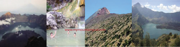
There over 20 villages surround Mt. Rinjani and there are many routes up the mountain,
but the main access is from Senaru in the north
and Sembalun Lawang to the east. The challenging three-day Rinjani Trek route
from Senaru to the crater rim (Plawangan), down to the stunning crater lake then
on to Sembalun Lawang, is considered one of the best treks in South East Asia.
Those heading for the summit usually prefer to start in Sembalun Lawang.
A model for ecotourism in Indonesia, the community-based activities are
focused on the Rinjani Trek Centre in Senaru, the most popular starting point
for the tough trek. Developed with New Zealand Government assistance since 1999,
the Rinjani Trek Centre embodies under one roof (satu atap) the unique
partnership of the National Park, tourism industry and local communities that
has been forged to manage and protect the Rinjani mountain environment.
WHAT YOU
MIGHT SEE
Gunung Rinjani National Park lies within the major transition zone (Wallacea)
where the flora and fauna of South East Asia makes a dramatic transition into
that which is typical of Australasia. The Park has a rich variety of plants and
animals, although they can be hard to spot due to the terrain and rainforest
cover.
Sometimes seen early in the mornings is the rare black Ebony leaf monkey, known
locally as Lutung.
The Long tailed grey macaque or Kera is common in Lombok and older males are
seen on the crater rim. Rusa deer are forest dwellers and are occasionally seen
along the Rinjani trek trail. The smaller Barking deer or Kijang has an alarm
call with a distinct dog-like bark. Look for the disturbed ground where the Wild
pig or Babi hutan has been foraging. Also found in the forest is the Leopard cat
or Bodok alas, Palm civet or Ujat and Porcupine or Landak.
A variety of colourful birds live in the forests of the Park. Perhaps the
best-known icon of the Park is the Sulphur Crested Cockatoo that is not found
any further west of Lombok. Many of the forest-dwelling animals, insects, birds,
civets and monkeys owe their survival to the wild fig tree or Beringin as a
provider of food and shelter. The pine-like Casuarina species, Cemara, are a
feature of the grassy higher slopes. Orchids or Anggrek are also a feature of
the grassland areas, as is Edelweiss or Bunga Abadi growing above the tree line;
it is a beautiful icon of the Park and one of our best-known sub-alpine plants.
Rinjani Trek Centre: The Centre is located at the trailhead above Senaru
traditional village. It offers information and displays for visitors on the
trek, the National Park, Sasak culture and a range of activities available in
Senaru.
Displays include maps, Park interpretation, village walks and environmental
guidelines. All trek arrangements can be made here, cultural tours booked and
purchases made of local produce and handicrafts.
Park Fees: Fees are paid at the Rinjani Trek Centre. They contribute to the
protection, maintenance and management of the National Park, Rinjani Trek
route, village attractions and visitor facilities.
Guides and Porters: Trained and licensed guides and porters are available. You
will need three days and two nights to trek from Senaru via the spectacular
crater lake, to Sembalun Lawang (or the other way). More time will be needed to
explore the summit of Mt. Rinjani.
All trek arrangements can be made and paid for at the Rinjani Trek Centre. If
not with a guide, please ensure you are well equipped and have knowledge of
mountain safety.
Warnings: The Rinjani Trek is a challenging mountain walk and you must be
prepared with good equipment, warm and windproof clothing. Rinjani can attract
severe storms, lightening and strong winds. When the weather is settled, the sun
is intense and the nights frosty. Parts of the trail are steep and slippery.
Beware of bad weather and risks of exposure to the wet and cold (hypothermia).
If caught in an electrical storm, take shelter and avoid prominent ridges.
Beware of snakes, and stinging insects and plants. Leeches can be a nuisance in
the wet season.
Volcanic Hazards: Although Mt. Rinjani has not erupted in recorded history, Mt.
Baru (2,363m) in the crater lake is an active volcano. It last erupted
dramatically in 1994. Check the notice boards for recent hazards, and take
advice from park staff and guides.
Spring Water: Fresh water springs are a feature of the trek and determine
campsites. Your guide knows where these are. During the drier months
(July-September) some springs completely disappear. Park staff and guides
constantly monitor these water sources to determine their abundance.
Radio Communications: You are advised to ensure that your guide is carrying a
radio handset. Radios are available for rent at the Rinjani Trek Centre. In case
of emergency the National Park authorities are also equipped with radio
communications.
Telephone Communications: There is a satellite telephone at the Rinjani Trek
Centre and the number is 086812104132. This is available for public use; cost is
dependent on call destination and duration.